 The
portal to your foray into the wonder and magic inn Stowe!

 Recommended
Hikes
 For
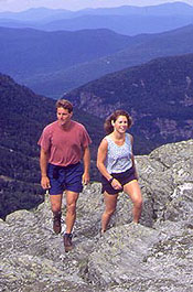
an afternoon of fun in Stowe take a ride on the shoe-leather
express. Go hiking! Stowe has a variety of trails to offer hikers of
all ability levels. The trail system in Stowe is well maintained
with clear paths and obvious trail blazes. Here are a few sample
hikes to get you trekking:
The Pinnacle Trail is a relatively
short hike located east of town. The trailhead in Stowe Hollow is a
2.8-mile drive from Main Street on mostly paved roads. From the
trailhead it's a 1.4-mile hike to the summit of the Pinnacle, a
2,740-foot peak in the Worcester Range (the eastern border of
Stowe).

Most of
the trail is a fairly gradual and unobstructed ascent up the west
side of the Pinnacle, although there is a short rocky section as you
near the top. At the summit you will find unparalleled views of the
town of Stowe below and Mt. Mansfield to the west.
Hiking
at a leisurely pace allowing time to enjoy the views takes about 2.5
hours round trip, while the physically fit can run the whole thing
in 50 minutes.
On the
opposite side of town lies the Long Trail,
a 265-mile trail system running throughout Vermont, which crosses
Mt. Mansfield and Spruce Peak in Stowe. From Stowe the easiest
access is in Smugglers' Notch, where there are two trailheads.
 One runs
north, from the top of the Notch to Sterling Pond. The trail is
steep and rocky for the first half mile, then flattens as it
traverses Spruce Peak. It is another half-mile to Sterling Pond and
a round trip total of 2 miles.
More
intrepid climbers can follow the Long Trail
South from Smugglers' Notch up Mt. Mansfield. This is one
of the steepest sections of the Long Trail; here the trail climbs
almost 3,000 vertical feet to the top of Mt. Mansfield (4,395 feet)
in 2.3 miles. It is flatter toward the bottom, fairly wide but
steeper through the middle, and very rocky at the top.
The
views are well worth the effort: From the summit you can see west
across Lake Champlain to the Adirondacks and on a clear day Mt.
Washington can be seen to the east. Bring warm clothes, water and a
picnic for an enjoyable day trip.

There
are many other hiking opportunities in the area. For more
information on hiking in and around Stowe, contact the Green
Mountain Club at 802-244-7037 or stop at the Arbor Inn which is the
satellite hiking information center for the GMC. We carry all
of the guides & maps plus additional information to help you make
the most of your stay in Stowe.
